Trail Walking Conamara Municipal District - Ballykine loop  - Photo
 M7184
M7184

User

© OpenStreetMap contributors
Length
Length
7.2 km
Max alt
Max alt
41 m
Uphill gradient
Uphill gradient
77 m
Km-Effort
Km-Effort  
8.2 km
Min alt
Min alt
18 m
Downhill gradient
Downhill gradient
78 m
Boucle
Boucle
Yes
Creation date :
2022-09-09 13:17:27.598
Updated on :
2022-09-19 17:32:13.527

(0 Reviews)

Walking
Walking
1h52
Difficulty : Very easy

Scan this QR Code to open this trail in the SityTrail application

FREE GPS app for hiking

Logo SityTrail SityTrail

IGN / Geographical institutes

Download SityTrail from the App Store Download SityTrail from Google Play

Logo SityTrail SityTrail World

The world is yours!

Download SityTrail from the App Store Download SityTrail from Google Play Download SityTrail on Huawei AppGallery

About

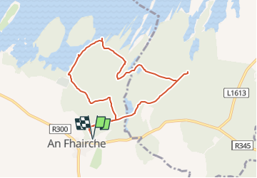
Trail Walking of 7.2 km to be discovered at Unknown, County Galway, Conamara Municipal District. This trail is proposed by M7184.

Description

An Fhairche
Parking aisé à côté de l'aire de jeu (Clonbur Wood car park), Aperçu de loin des ruines du Ballykine Castle et belles vue sur le lac "Lough Mask". Promenade facile,  chemin large et bien tracé

Elevation profile

Photos

Positioning

Country:
Ireland
Region :
Unknown
Department/Province :
County Galway
Municipality :
Conamara Municipal District
Location:
Cloonbur Electoral Division
Start:(UTM)
476071 ; 5933047 (29U) N.

Trails nearby

Trail Walking Conamara Municipal District - cong - Photo
Walking
bena42

Walking

Very easy
Conamara Municipal District, Unknown, County Galway, Ireland
3 km | 3.3 km-effort
46min
No


Close
My subscriptions